GeoPick

Implementing best practices for georeferencing

MDN

GeoPick is intended to be easy to use. You can move around the map and create and edit georeferences with the controls as explained below. Creating a georeference is as simple as locating the place of interest and drawing the geometry (point, line or polygon) that represents it. You can also use the search box to find a given location (e.g. a town, county, or state) from Nominatim, the search engine for OpenStreetMap data, and retrieve its corresponding geometry. Once displayed you may import the geometry and use it as your georeference.

Once you have the geometry on the map, either created by you or retrieved and imported from Nominatim, GeoPick will automatically calculate its corrected center, the coordinate uncertainty and precision, and the point radius spatial fit. The geodetic datum will be set to EPSG:4326 by GeoPick. The results will be shown in the right info column, along with the other georeferencing metadata. You will only need to fill in your name as georeferencer and any georeferencing remarks you may consider worth mentioning. Finally, you just need to click on the button to copy the data to the clipboard and paste them into a spreadsheet, with or without headers, and you are done.

Navigating the map
You can use the controls detailed below to move around the map.
Select among different map layers. Just hover with the mouse on top of the icon and a list of available layers will be displayed. Select the one you need.
Zoom in and out of a map; maintaining the center of the map at its current position.
Gives information on the coordinates where the cursor is placed and the graphical scale of the map (in meters and in miles)
Location search and import
You can use the horizontal bar centered on top of the map view to search for a given location.
Just type the name of a place and when the list of places found appears, select one. Its representing geometry, if available, will be shown. You can then click on the Import location button to use it as your georeference.

Once done, the string of the searched locality can be copied to the clipboard using the Copy button. In the example at the left, the Kilimanjaro locality would be copied.
Creating georeferences
You can use the controls detailed below to create lines or polygons representing the location of interest. Please note that you can create georeferences with multiple lines or polygons (e.g., a specimen is said to be collected in a forest composed of two patches). You just need to create a new line or polygon after the first is created and GeoPick will automatically recalculate the georeference parameters for the whole set of geometries.
Draw a point with a circle of uncertainty. Click at a location and drag to obtain the uncertainty circle.
Draw a line composed of multiple segments. Select it and start creating the line node by node. To finish the line, click on the Finish option offered by the tool or click again on the last node. To delete the last entered node click on the Delete last point option and, to cancel, click on the Cancel option.
Draw a polygon. Just select it and start digitising the polygon. To finish the polygon you need to close the polygon by clicking again on the starting node or by clicking on the Finish option offered by the tool. To delete the last entered node, click on the Delete last point option and, to cancel, click on the Cancel option.
Type the latitude, longitude and coordinate uncertainty to create a point with your exact values. You can also use this dialog to adjust the uncertainty of a point you have digitized with your mouse using the interactive tool.
Editing georeferences
You can use the controls detailed below to edit and delete geometries.
Edit point, line and polygon geometries. When selecting this option the nodes of the geometry will appear as small white squares. You can click on them and drag them around. Each time an existing node is selected, one node appears on each side of it at the midpoint to the to the next node. These nodes can also be clicked and dragged to make the geometry more detailed. You can also double-click on a node to delete it. When done editing the shape of the line or polygon, just click Save to finish. GeoPick will recalculate the georeferencing parameters and refill the info box with the new data. Click Cancel if you want to discard your changes. Please note that GeoPick may not work with some very complex geometries from Nominatim, with hundreds or thousands of nodes; depending on your computer capacities, the browser may not be responsive to dragging them.
Clear all geometries drawn on the map. Just click on the Clear All option, or click on Cancel if you decide not to clear anything.
Importing geometries in Well-known text (WKT) format
You can use the controls detailed below to edit and delete geometries.
geometries in the Well-Known Text (WKT) format as used in the Darwin Core footprintWKT term. Click on the button and paste your WKT geometry in the text area box that will appear (see example image below). Then click the OK button and you are done. GeoPick will calculate the smallest enclosing circle and uncertainty as if the geometry had been on-screen digitized. You can then also edit the geometry if you need to. Please note that MULTIPOINT and GEOMETRYCOLLECTION objects are not supported.
Getting georeference results
Use these three buttons to validate the georeference data and export data to the clipboard in a spreadsheet-friendly tab-delimited format.
Once you have filled in the Locality, Georeferenced by, and, optionally, the Georeference remarks in the Info box, you need to click on the Validate button to confirm the georeference data. Then you can export it. You just need to click on the With headers or Without headers button and all data will be copied to the clipboard. If you choose With headers, the headers (field names) of each georeference field will also be copied. On the contrary, if you choose Without headers, only the data will be copied. You may be georeferencing more than one location and this will serve you to copy the headers only for the first one. From the second on, you will be able to paste them in each following row of a spreadsheet without repeating column names.

NOTE: Some spreadsheets limit the number of characters per cell (e.g., Microsoft Excel: 32 767, Google Sheets: 50 000). Since some geometries can get quite complicated and exceed 32 767 characters, specially those imported from Nominatim, GeoPick lets the user decide whether to copy or not the WKT representation of the geometry when copying data.
Sharing georeferences
You can use GeoPick to share your georeferences with colleagues.
GeoPick will assign a unique ID to each georeference and provide you with a link, which you can share with your colleagues. The link will take the form of https://geopick.gbif.org/?locationid=<geopick_id>. This promotes collaboration with colleagues by allowing the quality of georeferences to be double-checked and by allowing georeferences to be shared. Even so, be sure to copy your georeference data into your database/spreadsheet because its long-term storage in GeoPick can not be guaranteed.
GeoPick also allows you to show a simple point-radius geometry to a colleague by using a parameterized URL in the form of
https://geopick.gbif.org/?lat=<latitude in decimal degrees>&lon=<longitude in decimal degrees>&unc=<coordinate uncertainty in meters>
When navigating to such a URL with a browser GeoPick will show the point-radius geometry.
A final note on uncertainty:

GeoPick gives coordinates with seven decimal places following Georeferencing Best Practices (Chapman and Wieczorek, 2022) and Georeferencing Quick Reference Guide (Zermoglio et al., 2022). This allows preservation of the correct coordinates in all formats regardless of how many transformations are done (Bloom et al., 2020; Wiezorek et al., 2010). Accordingly, GeoPick sets coordinate precision to a fixed value of 0.0000001, which is a decimal representation of the number of decimals given with the coordinates (Darwin Core Maintenance Group, 2021). Please also note that as in this version of GeoPick, 1.0, coordinate uncertainty refers only to the radius of the enclosing circle of the geometry and does not take into account other sources of uncertainty such as those derived from measurement accuracy and the accuracy of the underlying maps. To add this extra source of uncertainty please access the Georeferencing Calculator (Wieczorek C and Wieczorek J.R., 2021) and its manual (Bloom et al., 2020).

Keyboard shortcuts

You can use the following keyboard shortcuts to interact with GeoPick:

  • CTRL-T, CTRL-t: Start drawing a point.
  • CTRL-L, CTRL-l: Start drawing a line.
  • CTRL-P, CTRL-p: Start drawing a polygon.
  • CTRL-D, CTRL-d: Clear all geometries.
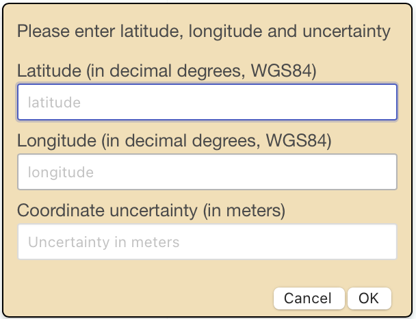
  • CTRL-K: Open point/uncertainty dialog box.
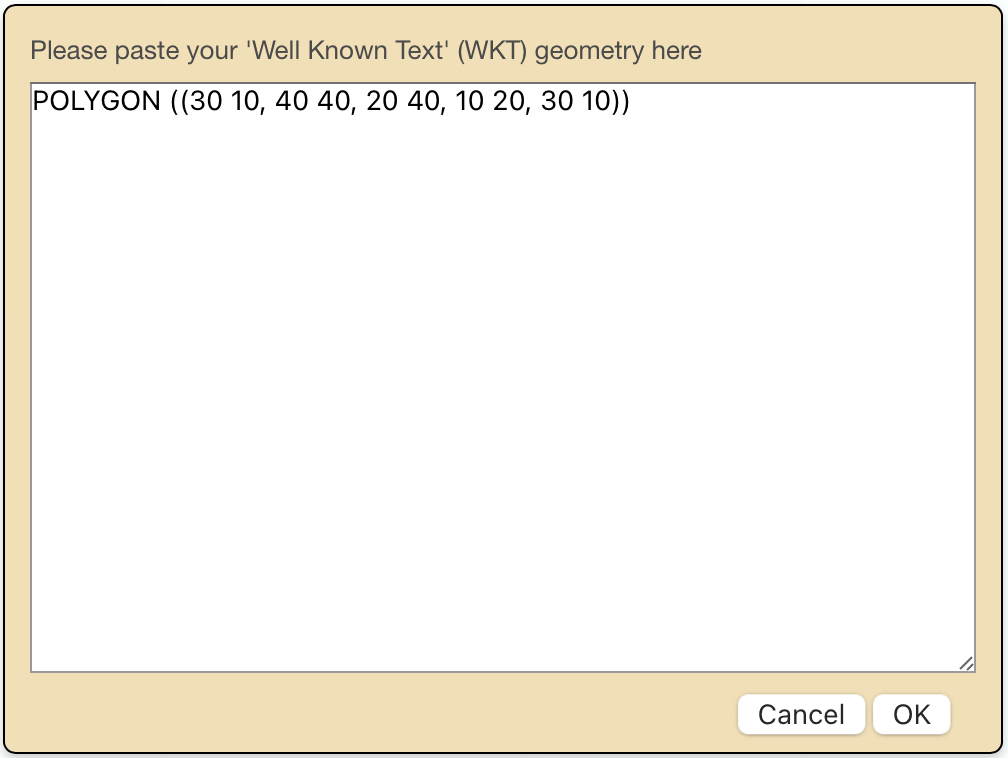
  • CTRL-W: Open WKT import dialog box.
  • CTRL-G: Set focus on Georeferenced by field.
  • CTRL-M: Set focus on Georeference remarks field.
  • CTRL-H: Copy data with headers.
  • CTRL-C: Copy data without headers.
  • CTRL-F: Fold/unfold info box.
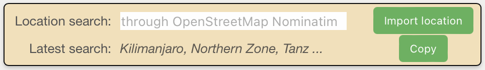
  • CTRL-S, CTRL-s: Set focus on Nominatim search field.
  • CTRL-I, CTRL-i: Import geometry from Nominatim.
  • CTRL-B, CTRL-b: Copy locality name of latest import from Nominatim.
  • ESC: Close dialog box.

Exported data
The following are the Darwin Core standard fields exported in tab-delimited format by GeoPick.
The geographic latitude (in decimal degrees, using the spatial reference system given in geodeticDatum) of the geographic center of a Location. Positive values are north of the Equator, negative values are south of it. Legal values lie between -90 and 90, inclusive.
The geographic longitude (in decimal degrees, using the spatial reference system given in geodeticDatum) of the geographic center of a Location. Positive values are east of the Greenwich Meridian, negative values are west of it. Legal values lie between -180 and 180, inclusive.
The ellipsoid, geodetic datum, or spatial reference system (SRS) upon which the geographic coordinates given in decimalLatitude and decimalLongitude as based.

Recommended best practice is to use the EPSG code of the SRS, if known. Otherwise use a controlled vocabulary for the name or code of the geodetic datum, if known. Otherwise use a controlled vocabulary for the name or code of the ellipsoid, if known. If none of these is known, use the value unknown.

The horizontal distance (in meters) from the given decimalLatitude and decimalLongitude describing the smallest circle containing the whole of the Location. Leave the value empty if the uncertainty is unknown, cannot be estimated, or is not applicable (because there are no coordinates). Zero is not a valid value for this term.

30 (reasonable lower limit on or after 2020-05-01 of a GPS reading under good conditions if the actual precision was not recorded at the time). 100 (reasonable lower limit before 2020-05-01 of a GPS reading under good conditions if the actual precision was not recorded at the time). 71 (uncertainty for a UTM coordinate having 100 meter precision and a known spatial reference system).

A decimal representation of the precision of the coordinates given in the decimalLatitude and decimalLongitude.
The ellipsoid, geodetic datum, or spatial reference system (SRS) upon which the geographic coordinates given in decimalLatitude and decimalLongitude as based.

Recommended best practice is to use the EPSG code of the SRS, if known. Otherwise use a controlled vocabulary for the name or code of the geodetic datum, if known. Otherwise use a controlled vocabulary for the name or code of the ellipsoid, if known. If none of these is known, use the value unknown.

The ratio of the area of the point-radius (decimalLatitude, decimalLongitude, coordinateUncertaintyInMeters) to the area of the true (original, or most specific) spatial representation of the Location. Legal values are 0, greater than or equal to 1, or undefined. A value of 1 is an exact match or 100% overlap. A value of 0 should be used if the given point-radius does not completely contain the original representation. The pointRadiusSpatialFit is undefined (and should be left empty) if the original representation is a point without uncertainty and the given georeference is not that same point (without uncertainty). If both the original and the given georeference are the same point, the pointRadiusSpatialFit is 1.

Detailed explanations with graphical examples can be found in the Georeferencing Best Practices, Chapman and Wieczorek, 2020 (https://doi.org/10.15468/doc-gg7h-s853).

A Well-Known Text (WKT) representation of the shape (footprint, geometry) that defines the Location. A Location may have both a point-radius representation (see decimalLatitude) and a footprint representation, and they may differ from each other.
The ellipsoid, geodetic datum, or spatial reference system (SRS) upon which the geometry given in footprintWKT is based.

Recommended best practice is to use the EPSG code of the SRS, if known. Otherwise use a controlled vocabulary for the name or code of the geodetic datum, if known. Otherwise use a controlled vocabulary for the name or code of the ellipsoid, if known. If none of these is known, use the value unknown. It is also permitted to provide the SRS in Well-Known-Text, especially if no EPSG code provides the necessary values for the attributes of the SRS. Do not use this term to describe the SRS of the decimalLatitude and decimalLongitude, nor of any verbatim coordinates - use the geodeticDatum and verbatimSRS instead.

The ratio of the area of the footprint (footprintWKT) to the area of the true (original, or most specific) spatial representation of the Location. Legal values are 0, greater than or equal to 1, or undefined. A value of 1 is an exact match or 100% overlap. A value of 0 should be used if the given footprint does not completely contain the original representation. The footprintSpatialFit is undefined (and should be left empty) if the original representation is a point without uncertainty and the given georeference is not that same point (without uncertainty). If both the original and the given georeference are the same point, the footprintSpatialFit is 1.

Detailed explanations with graphical examples can be found in the Georeferencing Best Practices, Chapman and Wieczorek, 2020 (https://doi.org/10.15468/doc-gg7h-s853).

A list (concatenated and separated) of names of people, groups, or organizations who determined the georeference (spatial representation) for the Location.

Recommended best practice is to separate the values in a list with space vertical bar space ( | ).

The date on which the Location was georeferenced.

Recommended best practice is to use a date that conforms to ISO 8601-1:2019.

A description or reference to the methods used to determine the spatial footprint, coordinates, and uncertainties.
A list (concatenated and separated) of maps, gazetteers, or other resources used to georeference the Location, described specifically enough to allow anyone in the future to use the same resources.

Recommended best practice is to separate the values in a list with space vertical bar space ( | ).

Notes or comments about the spatial description determination, explaining assumptions made in addition or opposition to the those formalized in the method referred to in georeferenceProtocol.